EADP19-001 Online Practice Questions and Answers
In a disconnected environment a data receiver fails to send acknowledgement messages often enough. How will the data sender respond?
A. Resends change messages
B. sends the next change messages
C. Slops sending change messages
D. Discards the change messages
Refer to the exhibits.
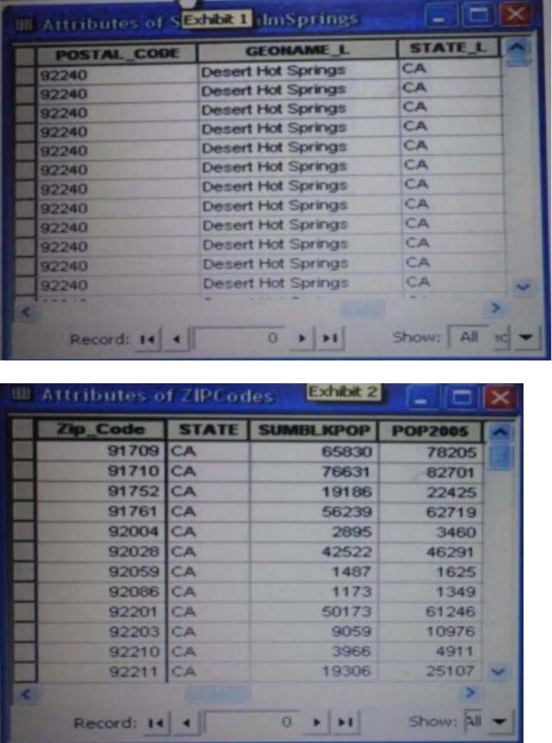
An ArcGIS user is attempting to create a relationship class between the two tables shown in the exhibit using POSTAL_CODE and Zip Code as the origin primary key and destination foreign Keys, respectively. However when the user tries to set the keys zip Cede does not appear in the drop-down list of candidate keys.
What should the user do to successfully create the relationship class?
A. change the relationship type from non attributed to attributed
B. make sure both tables are in the same geodatabase
C. create data type compatible key fields
D. move both tables to the same feature dataset
An ArcGIS user processes a point feature class using the Collect Events tool. The user finds that the output value for each feature is 1. Why did the tool only produce values of 1?
A. NONE of the points are co-located
B. mere is only one event to collect
C. All points are within a standard distance of one other point
D. The total value of all events adds up to 1
An ArcGIS user wants to create a hierarchy and differentiate cities on a map by categorizing the way the features are labeled. What should be used to achieve the desired result?
A. label expressions
B. label classes
C. label stacking
D. label priority
A raster dataset called rasterl.tif contains many pixels with values of NoData.
Which map algebra expression changes NoData values to 0 (zero) in the output raster dataset while leaving all other pixel values the same?
A. con(rasten.tif = NoData. 0 raster!, tif)
B. con(rasten.tif = = NoData, 0, rasterl.tif)
C. con(isnull(raster1.tif). 0, rasterl.tif)
D. con(setnull{raster1.tif), 0, rasterl.tif)
A layer tiding simple symbology is causing slow drawing performance at a scale where analysis needs to be conducted. Only certain features from this layer are necessary in order for analysis to be completed by the ArcGlS user. What can the user do to increase drawing performance?
A. reproject the layer
B. run the MXD doctor on the map document
C. apply a definition query
D. set a scale range to hide the layer
An ArcGIS user in a county office receives a large volume of data In shapefiles, coverages and table formats. The user is responsible for converting the data to a standard feature class format and writing it into a central enterprise geodatabase. The data must be simultaneously available for editing and spatial analysis tasks.
How should the Windows Task Scheduler be used to achieve these goals?
A. schedule to run a geoprocessing service with (he [asks and maintain log of script validation errors
B. schedule to run a geoprocessing service with the tasks and allocate a specific lime to run each task in the service
C. patch the tasks in a script and schedule to run the script at a scheduled time at non- peak hours
D. patch the tasks In a model and schedule to run the model at a scheduled time at non- peak hours
Four emergency response facilities need to be placed so that the greatest number of people in a community can be reached within five minutes.
Which analysis method is used to make this determination?
A. location allocation
B. closest facility
C. route
D. Dufer
An ArcGIS user wants to symbolize the intersections of highways and streets so that the road casing symbols can be blended together to represent connectivity, but not blended in other situations to represent disconnectivity (e.g. where a
highway passes under a surface street).
What should be used to ensure that the road casings connect correctly?
A. symbol-level drawing with the join option
B. symbol-level drawing with the merge option
C. multi-layered symbol with one layer wider than the other
D. single layered symbol with two offset lines
An ArcGIS user plans to distribute a series of map documents where the amount of time the map file can be viewed is limited. Which format should the user create to specify a timeout period for these maps?
A. mpk
B. ipk
C. pmf
D. msd

Home | Contact Us | About Us | FAQ | Guarantee & Policy | Privacy & Policy | Terms & Conditions | How to buy
Copyright © 2026 pass4itsure.com. All Rights Reserved